Metadata-Augmented Neural Networks for Cross-Location Solar Irradiation Prediction from Satellite Images
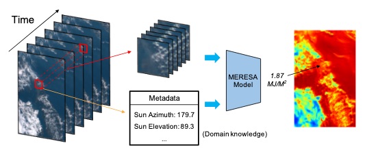
Photovoltaics (PV) energy has witnessed a rapid growth in the passing years [13], raising the importance of monitoring the efficiency of PV generation. Monitoring can be based on measuring the ratio of real to optimal production in a period of time. Optimal production is derived from solar irradiation1that conventionally referred from preset pyranometers. In this work, we proposed to estimate solar irradiation in a time period through processing a series of satellite images (See Fig.1). With a novel fusion method of important single-valued metadata (Sun position) and an autoencoder to leverage the spatiotemporal recurrence of satellite images, our method could reliably provide irradiation measurements in scenarios where pyranometers are unavailable (e.g. arbitrary lo-cation) or malfunction (e.g, dust, miscalibration). Our method per-formed on par with the state-of-the-art meteorological model and predictions closely aligned with ground truths from meticulously maintained pyranometers. Moreover, the Mean Absolute PercentError (MAPE) is 25% lower than that of Solargis, a commercialized solar data provider designated by The World Bank Group.
